

Flows have improved, but for how long? Water official says Colorado needs to start planning for the worst. Why hasn’t it?
by Allen Best
Andy Mueller, the general manager of the Colorado River District, delivered a strong message at the organization’s annual seminar in September. It was time, he declared, for Colorado to plan for potential curtailment of Colorado River diversions as necessary to comply with the compact governing the river among the seven basin states.
Compact curtailment, sometimes described as a compact call, means that those with water rights junior to or filed since the Colorado River Compact of 1922 would be vulnerable to having no water. That could potentially include most of Colorado’s Front Range cities, which get roughly half of their water from the Colorado River and its tributaries. It could also include some towns and cities on the Western Slope and even some farmers and ranchers on the Western Slope as well as some ag users reliant upon transmountain diversions.
The precise trigger for such a call, reduced flows to lower-basin states, is open to argument. An ambiguous clause in the compact could be hotly debated, and likely will be, if river flows continue to decline. Mueller spoke of legal saber rattling by lower basin states.
This is not entirely a new subject. Colorado has been talking about the potential for compact curtailment for about 20 years but has not pursued it. The state government disputes the immediate need. What almost everyone can agree upon, however, is that it will be foolish to assume that the near-average or better river flows of the last two years will prevail.
Reservoir levels in the basin have been sagging for most of the 21st century. Most dramatic was the runoff in 2002 when the river yielded only 3.8 million acre-feet. Delegates of the seven basin states who had gathered near Santa Fe in 1922 to apportion the river assumed average flows of at least five times that much.
Flows in 2003 and 2004 were only marginally better. Slowly, there was acceptance of extended drought unknown in the 20th century. In 2017, a study by Brad Udall and Jonathon Overpeck identified warming temperatures as just as important as drought in explaining the declines. They called it aridification.

In May 2022, the water of Powell had declined to about 22% of capacity, provoking questions whether the reservoir would have enough water in another year or certainly two to generate electricity. A track used in construction of Glen Canyon had emerged that spring from the receding waters, the first time it had been above water since the 1960s. Photos/Allen Best

It might have worsened. Modeling evaluated the risk of Powell having too little water to generate electricity by the next year. Some talked about potential for the reservoir to have too little water to pass any downstream, what is called dead storage.
Instead of further decline, snow fell in prodigious quantities during the next winter of 2022-2023 across parts of Colorado, which is responsible for 55% of total flows in the river, as well as in Wyoming and other upstream locations. Stock fences were entirely buried in some places of the Yampa Valley.
The runoff that resulted was the third-best in the Colorado River in the 21st century. Five more consecutive runoffs of the same magnitude would fill Powell and all the other reservoirs in the Colorado River Basin, according to Utah State University’s Jack Schmidt.
What if, instead of epochal snows in the Rockies, pitiful runoffs parallel to those of 2002 to 2004 return?
“Let’s hope for the best and plan for the worst,” Mueller said at the seminar in Grand Junction held by the River District. The Glenwood Springs-based district — its official title is the Colorado River Water Conservation District — was created in 1938 to represent the interests of 15 of the 20 counties on the Colorado River drainage.
Several people who heard Mueller’s remarks applauded them. Colorado, they say, should not wait until the very last minute before devising a strategy. Curtailing water use will be a very difficult and lengthy process. Better to get on it now.
But there is also another level to the discussion, one of moral and ethical questions, according to one long-time Colorado Rive observer
“How do we, as a community of two nations, seven states and Mexico, and 30 sovereigns (Native American tribes) — how do we come together to recognize that this is a shared resource, and climate change is changing the resource. We need to understand how to collaboratively share the resource in a way that will be necessary to live in a climate-altered world,” says John Fleck, an Albuquerque-based author of several books, including “Water is for Fighting Over: And Other Myths about Water in the West.”
Colorado and other upper basin states, he observes, are saying it’s not their problem because they have met their commitments.
”That is morally wrong to me,” he said in an interview. As a practical matter, it’s also “seems really dumb” because in the political and legal system the upper basin states are unlikely to win that argument in a drier 21st century. “That just ain’t gonna work.”

The Colorado River Compact of 1922 apportions waters between the upper and lower basins. Lee Ferry, just a few miles below Glen Canyon, along the Utah-Arizona border, divides the two. Water from the river is also exported outside the basin to agriculture areas of eastern Colorado and cities of the Front Range as well as southern California, Albuquerque and other places.
Non-depletion obligation
The 1922 compact apportioned 7.5 million acre-feet for the upper basin states – Colorado as well as New Mexico, Utah and Wyoming — and 7.5 million acre-feet for the three lower basin states of Arizona, California and Nevada. The compact assumed deliveries to Mexico would be required by a future compact, and they also realized significant evaporation. Altogether, they assumed more than 20 million acre-feet flows in the river. That has rarely happened.
The debated clause is called the “non-depletion obligation.” It says the upper basin states must allow river flows of 75 million acre-feet over a rolling 10-year average at Lee Ferry. Lee Ferry is in Arizona, just below Glen Canyon and a few miles above the Grand Canyon.
Colorado’s position is two-fold. It argues that the lower basin overuse remains the primary problem coupled with climate change. And Colorado and its siblings in the upper basin didn’t create either.
“We take the position that we are not the cause of trending lower flows over the past 20 years,” said Jason Ullman, the state water engineer in a statement from the Colorado Department of Water Resources in response to a query by Big Pivots. “Climate change and aridification impact snowpack and soil moisture, which in turn reduce flows into the Colorado.”
Colorado and other upper-basin states altogether use between 3.5 and 4.5 million acre-feet annually compared to roughly 10 million acre-feet by the lower-basin states.
“This is why Colorado believes that the responsibility to bring the river back into balance primarily lies with the lower basin and the need to bring uses within their compact apportionment with a plan to use less during times of shortage,” Ullman said.
Mueller, in his remarks at Grand Junction, didn’t disagree with that stance. But he insisted that Colorado needs to prepare a backup plan if the state must releases more water downstream, forcing the curtailment of its diversions.
“I think the best thing our state can do is, while continuing to make a very good case that we’re not the cause of this and that climate change is causing it, we need to be prepared in the event it occurs,” said Mueller
River District directors had recently asked Ullmann to “please get moving with compact curtailment rules,” he said.
The state needs to come up with the “right funds, have the right personnel, and get moving with our compact curtailment rules,” said Mueller.
This, he added, should not be seen as a sign of weakness by Colorado in the interstate negotiations, but rather as a sign “that we’re smart, that we’re helping our water users and our communities plan for the future.”

After another drought year in the San Juan Mountains, most of the Ute Mountain Ute center-pivot sprinklers were idle in May 2022. Shiprock, in New Mountain, rises in the distance amid smoky skies. Photo/Allen Best
Colorado and other basin states are in the midst of negotiating new guidelines that govern operation of the two big reservoirs, Mead and Powell. The first set of guidelines were adopted by the states and the Bureau of Reclamation in 2007.
The regulations were abetted by the drought contingency plan, which brought cuts in water use to the lower basin and new water management tools to the upper basin.
The 2007 guidelines expire at the end of 2026. The states must come up with a new agreement that recognizes the shifted realities by the end of 2025.
State government does not absolutely reject the need for compact compliance rules, but the statement attributed to Ullman cites these negotiations.
“It would be imprudent to undertake any rulemaking for compact compliance without knowing the terms of any seven-state consensus regarding operating guidelines that includes releases from Powell. Therefore, it is the position of the state engineer that undertaking compact compliance rulemaking now would be premature.”
That sounds like no. But there’s more.
The state engineer has the exclusive authority to make and enforce regulations that enable Colorado to meet its compact commitments.
“Colorado recognizes that the first critical step in being able to administer to the compact, if necessary, is the ability to accurately measure diversions,” said Ullman in the written statement. “The state engineer is pursuing measurement rules for diversions to establish accuracy standards and better define where measurement is necessary. The goals of this effort include increasing the consistency of water right measurement so that Colorado sends only what is required to maintain compact compliance and not more.”
How much Colorado might have to curtail would depend upon findings of the Upper Colorado River Commission, which is governed by a 1948 compact.
The state engineer has adopted rules for one of the four water divisions on the Western Slope, and work is progressing in a second district. The engineer plans to also adopt measurement rules in the other two districts.
What do the big Front Range diverters with post-compact water rights have to say?
Denver Water falls in line behind the state position. It has major diversions from the Colorado River tributaries in Grand and Summit counties.
“We recognize interest from some in rules for compact administration, but it’s very important that this effort be undertaken at the right time, with thoughtful collaboration among water interests statewide. We know that the State Engineer laid out a potential process a few years ago, with the first step being a focus on measurement rules. If and when it becomes necessary to take further action, we trust the State Engineer to so do. In the meantime, we think it’s critical that states, including Colorado, should keep their focus on the post-2026 guidelines being negotiated now, and not be distracted during a process of the greatest importance to Colorado’s future.”
Northern Water, operator of the Colorado Big-Thompson diversions from the Colorado River headwaters in Grand County, says it will defer to the state. “Northern Water looks to the State of Colorado as the leader on matters related to interstate water agreements,” said public information officer Jeff Stahla.
“A new different”
Mueller has used the same forum in years past to warn of a worsening situation in the Colorado River Basin. Two years ago, for example, he warned that flows were already well below the 20th century averages. Might those flows of 13.5 to 14 million acre feet further decline to 9.5 million acre-feet in decades ahead?
See: “Pick your Colorado River metaphor: The river is in deep doo-doo, and worse may very well come. So why such a sluggish reaction?” Big Pivots, Sept. 30. 2022.
Even relatively healthy snowfalls don’t necessarily produce robust volumes of runoff. For example, snow during the winter of 2023-24 was good but runoff just 84% of average.
“A new different” is how Dave Kanzer, the River District’s director for science and interstate matters, described the runoff numbers.
“We are just kind of treading water, and where we are next year could be similar to where we are this year — unless something changes,” he added during the district’s seminar in Grand Junction. “There’s a lot of uncertainty.”
Warming temperatures most likely will produce continued declines in river flows. That was a key takeaway of the presentation by Russ Schumacher, the state climatologist. He’s a careful scientist, clear to differentiate what is known from that which is not. Much of what he said was not particularly new. Some of the conclusions he offered were little changed from those of a decade ago – but with one key difference. Another decade of data has been compiled to support those conclusions.
Seven of Colorado’s nine warmest years have occurred since 2012. The rise can be seen most clearly in summer and fall records. This past summer was part of that trend. It was the sixth hottest summer in Colorado’s recorded history going back to the late 1800s.
Some places were hotter than others, though. In Grand Junction, gages at Walker Airfield recorded the hottest June-August period ever, an average of more than 80 degrees. That’s the average temperature 24/7, day and night.

Integration of temperature and precipitation records tell a more complex and concerning story. Rising temperatures have produced earlier runoff. The warmth also exacerbates evapotranspiration, which is also called evaporative demand. The warmer it is, the more surface air draws water from the plants and dries out the soils.
The most powerful way of explaining all this was in two sequences of slides, one of which is reproduced here.
“The timing shift, even if the peak doesn’t change all that much – the timing is quite important,” said Schumacher. Colorado River flows at Dotsero, near Glenwood Canyon, have already declined 25% during late summer.

Schumacher and other scientists describe predictions with various degrees of confidence. There is, he said, high confidence of a future warming atmosphere that to an even greater degree reduces runoff no matter how much snow falls in winter. We can be sure of temperatures rising between one and four degrees F by mid-century, he said.
Unless Colorado gets far more snow and rain, the Colorado River will decline further.
Future warming depends upon how rapidly greenhouse gas emissions rise globally. In mid-October, they were at 418 parts per million high on the slopes of Hawaii’s Mauna Loa. They were 315 when the first measurements were taken there in 1958 and roughly 280 at the start of the industrial era.
All of Schumacher’s presentation is valuable, as is his slide deck. Both can be found on the River District website under the annual seminar heading.
And that returns us to the Colorado River Compact, the foundation for deciding who gets what and where in the basin — and who doesn’t.
Flows over the last 10 years
In 1922, when the Colorado River Compact was drawn up at a lodge near Santa Fe, the Colorado River had been producing uncommonly robust flows. In their 2019 book, “Science Be Dammed,” Fleck and Eric Kuhn, the former general manager of the River District, explained that ample evidence even in 1922 existed of drier times just decades before. Later evidence documented lesser flows in the centuries and millennia before.
Not only were flows in the Colorado River during the 20th century much less than was assumed by the compact, the document failed altogether to acknowledge water rights for Ute, Navajo and 28 other Native America tribes in the basin who were to get water as would be necessary to sustain agricultural ways of life. Just how much had not been determined, although it’s now estimated at 20% of the river’s total flow. Some claims still have not been adjudicated.
Mueller called it a “flawed document” produced by a “flawed process” that had “faulty hydrological assumptions” and did not include “major groups of people who reside in and own water rights in this basin.”
For its time, though, the compact was a grand bargain. Colorado’s Delph Carpenter was a key negotiator. He had realized that if diversions from the Colorado River were determined by the doctrine of prior appropriation, the bedrock for water law in Colorado and most other states, the upper-basin states would lose out because they would develop the Colorado River more slowly. Instead, the compact created an equitable apportionment, essentially a 50-50 split of the water between upper and lower-basin states.
It was the foundation for what is now called the Law of the River, by which is meant the many laws, court decrees and agreements concerning both surpluses and droughts.
Dams were built, diversion structures constructed – including, because of a law of Congress in 1968, the Central Arizona Project (which also resulted in dams on the Animas and Dolores rivers in Western Colorado). That 1968 legislation, the Colorado River Basin Project Act, recognized that the river would be short by as much as two million acre-feet, said Mueller.
And then the agreements of the 21st century have tried to acknowledge lesser flows. But they have also deferred the really hard questions. The harder questions, as Mueller suggested, may yet provoke the states to get out their legal swords.
Central to the dispute is how much water should the upper basin states be releasing from Lake Powell? This is the key clause in the compact: “The States of the Upper Division will not cause the flow of the river at Lee Ferry to be depleted below an aggregate of 75,000,000 acre-feet for any period of ten consecutive years …”
Flows from Colorado and other upper-division states have been about 86 million acre-feet over the last 10 years.
Lower-basin states say no, that’s not enough. They argue that the upper basin states need to accept cuts, too.
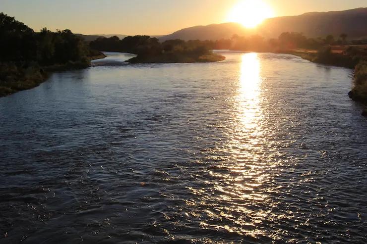
Andy Mueller, general manager of the Colorado River District, warns that Colorado must be prepared for lesser flows in the Colorado River, seen here at sunset in September 2022 at Silt. Photo/Allen Best
For now, there is no dispute that the upper basin states are meeting that obligation. But what if a string of years like those of 2002-2004 return? And what if the case ends up before the Supreme Court and that court ultimately rules against the upper basin?
This sets up the potential – Mueller characterized it as a certainty – for conflict, a court case that will have to go before the U.S. Supreme Court.
“I don’t believe we’re violating the compact today, and I don’t think we’re going to be violating the compact necessarily if the river drops, if our delivery below Glen Canyon drops,” he said. “What I can tell you is we’re going to have litigation.”
Colorado, Mueller asserted, must put together rules for how it will handle shortages if the state must curtail it diversions in order to allow water to flow downstream. He called it a painful process but warned that the “future is not far away.”
The River District position is that the burden within Colorado cannot fall entirely on the Western Slope and its ag users. Programs designed to reduce compensation have been focused solely on the Western Slope and agriculture, says Lindsay DeFrates, deputy director of public relations.
“If we are looking to reduce water long term, we can’t put it on the backs of West Slope users,” she says. “It has to be a shared burden.”
Journalists insist that it’s Western Slope. People in the water community invariably say “West Slope.”
On the slow-moving train
I wrote my first story about this possibility for a magazine in 2009. It may have been the first such story in the popular press, but even in 1951 a legal advisor delivered a memo to state officials on this topic. For a sorting through of the legal issues published in 2012, see: “Does the Upper Basin have a Delivery Obligation or an Obligation Not to Deplete the Flow of the Colorado River at Lee Ferry?”
“Having a state plan for compact curtailment has been on the table for what seems like forever, likely 2005 to 2007,” said Ken Neubecker. Now semi-retired, he has been carefully watching Colorado River affairs for several decades and has represented several organizations at different times.
Why hasn’t Colorado moved forward with this planning? When I called him to glean his insights, Neubecker shared that he believes it’s because such planning encounters a legal and political minefield.
“It’s not as simple as pre-1922 rights are protected and post-1922 rights are going to be subject to curtailment based on the existing prior appropriation system.”
Front Range municipal water providers and many of Colorado’s agriculture diversions are post-1922 compact. And so are some agricultural rights on the Western Slope.
“I think everybody thinks that well, we’re on the slow-moving train and the cliff is getting closer but it’s not close enough – and there are other things that we can do to slow the train down.”
Taylor Hawes, who has bee n monitoring Colorado River affairs for 27 years, now on behalf of The Nature Conservancy, suspects that Colorado doesn’t want to show its legal hand or even admit the potential need to curtail water use in Colorado. She contends that planning will ultimately provide far more value.
“The first rule you learn in working with water is that users want certainty. Planning is something we do in every aspect of our lives, and planning is typically considered smart. It need not be scary,” she told Big Pivots. “We have all learned to plan for the worst and hope for the best.”
Colorado can start by creating a task force or some other extension of the state engineer’s office to begin exploring the mechanisms and pathways that will deliver the certainty.
“We don’t have to have all the answers now,” Hawes said. “And just because you start the process for exploring the mechanism to administer compact compliance rules doesn’t mean you implement them. It will give people an understanding of what to expect, how the state is thinking about it.”
Lessons from Colorado’s other river basins
Compacts have forced Colorado to curtail diversions in three other river basins: the Arkansas, Republican and Rio Grande. The Rio Grande offers a graphic example of curtailment of water use as necessary to meet compact obligations on a week-by-week basis.
The Republican River case is a more drawn-out process with a longer timeline and a 2030 deadline. In both places, farmers are being paid to remove their land from irrigation. The Colorado General Assembly this year awarded $30 million each to the two basins to bolster funding for compensation.
A study commissioned by the Nature Conservancy that involved interviews with water managers and others in those river basins had this takeaway message: “the longer (that) actions are delayed to address compact compliance, the less ability local water users have to tailor compliance-related measures to local conditions and needs and reduce their adverse impacts.”
In the Arkansas Basin, Colorado had to pay $30 million and water available to irrigators was reduced by one third.
“That’s the first lesson in how not to do compact compliance: do not wait to be sued because (then you lose) the flexibility to do stuff the right way,” said one unidentified water manager along the Arkansas River.

River compacts have caused Colorado to curtail diversions from several of its basins, including the South Platte River, seen here on a hot summer afternoon near Platteville, between Greeley and Denver. Photo/Allen Best
Neubecker points to another basin, the South Platte. Even in 1967, Colorado legislation recognized a connection between water drawn from wells along the river and flows within the river. The 2002 drought forced the issue, causing Hal Simpson, then the state engineer, to curtail well pumping, creating much anguish.
Creating a curtailment plan won’t be easy, Neubecker warns. “It could easily take 10 years. ’Look how long it took to create the Colorado Water Plan. It took a couple years and then we had an update five years later. And that was easy compared to this.”
All available evidence suggests the Colorado River Basin states are nowhere near agreement.
In August, Tom Wilmoth provided a perspective from Arizona in a guest opinion published by The Hill under the title of “Time is running out to solve the Colorado River crisis.” As an attorney he has worked for both the Arizona water agency and the Bureau of Reclamation before helping form a law firm in 2008.
“It has taken 24 years for the problem to crystalize, but less than 24 months remain to develop a solution,” he wrote. “Yet there appears to be little urgency in today’s discussion among the Colorado River Basin’s key players.”
Wilmoth said ”Deferring hard conversations today increases the risk of litigation later.” He, like all others, sees a reasonable chance it would end up before the Supreme Court – with the risk of the justices appointing a special master to adjudicate the conflict. “Its recent tendency has been to appoint individuals lacking in subject matter expertise, a troubling prospect given the complex issues at play.”
Cuts must be made — and shared
Monitoring the conversations from Southwest Colorado, Rod Proffitt sees Mueller trying to prepare people in the River District for the challenges ahead.
“I think he has tried to scare people. He is trying to get them prepared to make some sacrifices, and limiting growth is a sacrifice.”
Proffitt is a director of the Pagosa Springs-based San Juan Water Conservancy District.
A semi-retired water attorney, Proffitt is also a director of Big Pivots, a 501-c-3 non-profit.
Make no mistake, says Proffitt, more cuts in use must be made – and they need to be shared, both in the lower basin and in the upper basin. What those cuts need to be, he isn’t sure. Nor do they necessarily need to be the same.
For example, he can imagine cuts that are triggered by lowering reservoir levels. At a certain point, lower basins must reduce their use by X amount and upper basin states by Y amount.
The federal government has mostly offered carrots to the states to reduce consumption, a recognition of the river’s average 12.4 million acre-feet flows, far short of the flows assumed by the compact. It also has sticks, particularly regarding lower-basin use, but has mostly avoided using its authority. Instead, the lower-basin has reduced use voluntarily, if aided by the federal subsidies.
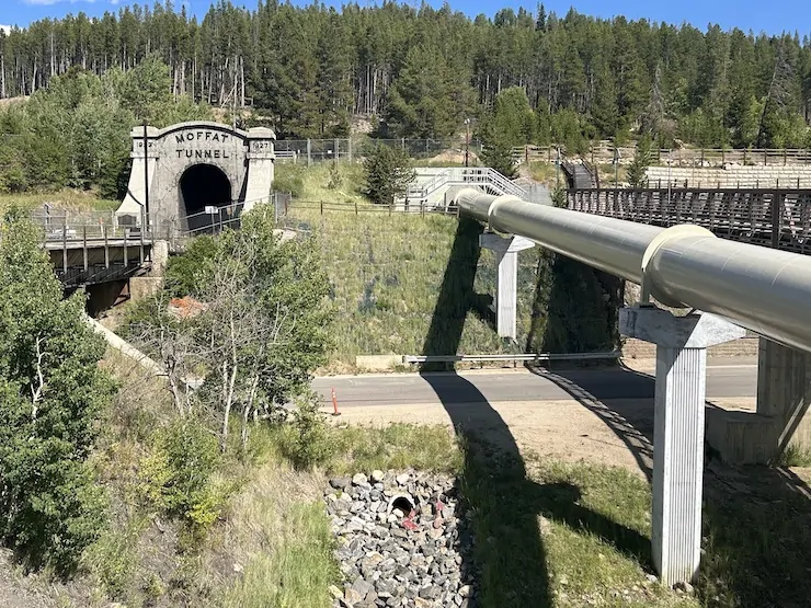
About alf of the water for cities along Colorado’s Front Range comes from the Colorado River and its tributaries, including through this Moffat bore at Winter Park. Photo/Allen Best
The Inflation Reduction Act and the Bipartisan Infrastructure Law, have delivered a river of money for projects in the West that broadly seek to improve resiliency in the face of drought and climate change. The seeds have been planted in many places. For example, a recent round of funding produced up to $233 million for the Gila River Indian Community in Arizona for water conservation efforts.
The federal government has also offered incentives to reduce consumption in the upper basin. The System Conservation Pilot Program ran from 2015 to 2018. The 2024 program was funded with $30 million through the Inflation Reduction Act and had hopes for conserving about 66,400 acre-feet.
The federal government, through the Bureau of Reclamation, has clear authority to declared water shortages in the lower basin. It has warned that three million acre-feet less water must be used. The lower-basin argues that the upper basin should share in some of this burden.
Not enough vinegar!
Should the federal government get out the stick?
“Nobody wants to apply vinegar this close to the November election,” said James Eklund when we talked in late September about the stalemate on the river.
Eklund has had a long association with the Colorado River. His own family homesteaded on the Western Slope near Colbran in the 1880s and the ranch is still in the family. He lives in Denver, though, and was an assistant attorney in the state attorney general’s office in 2009, when I wrote my first story. He later directed the Colorado Water Conservation Board, the lead agency for state policy.
For the last few years Eklund has been on his own, more or less, a water attorney now working for Sherman and Howard, a leading Denver firm, while trying to represent clients with diverse agriculture water rights.
“Litigation is a failure,” he said when I asked him about Mueller’s remarks in Grand Junction. He contends the upper basin must come to the table with more ideas about how to solve the structural imbalance between supplies and demands than it has so far. And this, he said, will involves some pain.
Creating compact curtailment will involve rule-making, though, and that will take time and effort. Echoing Denver Water’s position, he says it will divert Colorado from the more important and immediate work of helping negotiate solutions.
Eklund suspects an ulterior motive of the River District: to get the state to play its cards on what curtailment could look like so that it can begin jockeying for position.
On the other hand, he believes cutbacks should be premised on two bedrock principles: voluntary and compensated. But Eklund also says that if the situation becomes desperate enough, water will continue to find its way to cities. “The Front Range is not going to bend its knee to alfalfa plants. It’s not going to do it.”
And then, Colorado’s Constitution allows municipalities to take water. It requires compensation.
California has cut back its use from 5.1 million acre-feet to its apportionment of 4.4 million acre-feet in the last 20 years, part of the lower basin’s reconciling some of its past excesses with the new climate-driven reality. December 2015 photo/Allen Best
The Bureau of Reclamation has said the same thing in the lower basin. Las Vegas and other cities will not be allowed to dry up.
But what if compact curtailment means making the hard decision about who doesn’t get water and does not get compensated – people like the farmers near Fort Morgan who, in 2002, had to cease pumping water?
Neubecker characterizes the position of Colorado as one of conflict avoidance. Look at where it got Neville Chamberlain, the British prime minster, in his negotiations with Hitler.
What Colorado must do is prepare for the worst-case scenario. “It’s a doomsday plan,” Neubecker says of compact curtailment. “Make the plan, involve all the people who are going to be effected by the plan, and put it on the shelf – but not too far back on the shelf, just in case you need it”
For now, water levels in the two big reservoirs are holding more or less steady.
Another winter like 2002 could trigger renewed clanging of alarm bells.
In New Mexico, Fleck, the author, who also monitors Colorado River matters at his Inkstain blog, rejects the metaphor of the Titanic or the idea that conflict is inevitable. In 2002, California was still using 5.1 million acre-feet from the Colorado River, both for agriculture and to supply the metropolitan areas of Southern California. This was well above the state’s apportionment of 4.4 million acre-feet. “The rhetoric was that it will be a disaster to California’s economy” to return to the allocated flows.
California eventually did cut back and it has done just fine. “Everybody would prefer not to do the adaptation, but they have done it just fine. We see that over and over again in community responses to drought in the Western United States,” he said.
Lake Powell currently has filled to 40% of capacity, a marked improvement from February 2023, when the reservoir had fallen to 22% of capacity. Mead is at 36% of capacity. The situation is not as tense as it was two years ago. That could change in the blink of another hot, dry runoff like that in 2002.
- Is Colorado project a victim of Trump ire? - July 26, 2026
- A new low on the Colorado River - July 15, 2026
- Water trial of the century - July 14, 2026
